Photo Gallery: Sidestreet Scenes
|
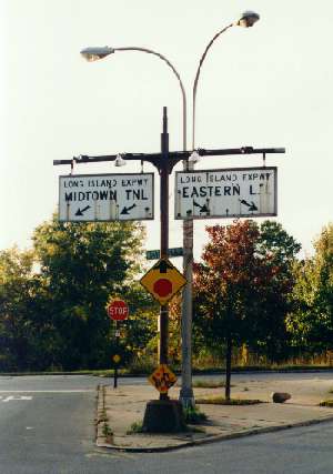
Facing north, at the corner of Douglston Pkwy, coming from
the south and heading to the right and West Alley Road, heading
to the left. The traffic island is the home to a rare original Long Island Expwy directional sign, from the 1950's. The LIE is a couple of blocks away, in either direction. A wildlife refuge patch exists behind the trees in the background, alongside the Cross Island Pkwy. I believe it is a part and parcel of the greater wetlands refuge north of the LIE, technically part of Alley Pond Park, whose peoples refuge can be accessed a couple of blocks up West Alley Rd, unseen to the left. |
|
|---|