
Brooklyn-Queens BQE Red Hook Carroll Gardens Northbound
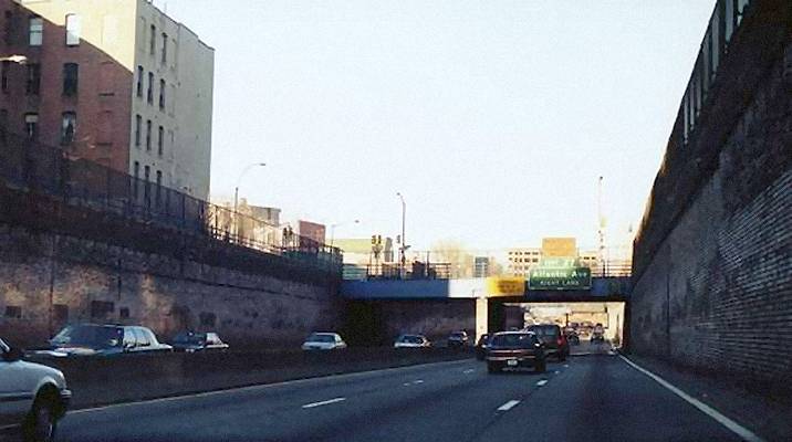 The I-278 Interstate Brooklyn Queens Expressway passes through its starkest open cut run out of its several such incarnations. This open cut section dating from the 1950s was lined with what may have once been bright fire engine red brick facing. From the time I first remember it however, in the early-mid 1960s and forever onward, these bricks, the ones that actually survived still clinging to the concrete behind them, were never any brighter than a dirty, dark, dingy, angry, downright murderous, brownish crimson.
In comparison, the buff colored concrete and occasional stone facing lining other open cut sections were bright and cheerful.
This one relatively short section of the BQE has one other unusual feature, unusual that is for the BQE; it is straight and level. Most of the other distinct sections of the Brooklyn Queens are winding and only slightly more level than a roller coaster. The only other true Brooklyn Queens straightaway is the Gowanus elevated stretch in Sunset Park, but whether that section counts as truly being part of the BQE is open for debate, many considering the Gowanus a standalone highway sharing nothing with the BQE but the Interstate route designation.
The top view is approaching Kane Street and below is approaching Congress St. The right side of the highway (or at this point; lowway) is the gentrified brownstone oasis of Carroll Gardens. For those of you familiar with the F train subway line, that's the Bergen and Carroll Street stations. The neighborhood to the left is sort of, part of Red Hook. It was long neglected, but is now also gentrified. There's not much to it, because the piers are only a block away. Carroll Gardens was one of those old-line Italian neighborhoods, like Little Italy, West Greenwich Village, Gravesend and parts of Bensonhurst. It still retains much of the flavor of the old days.
Those who've seen the American Experience episode on PBS, about Robert Moses, may recognise this part of the BQE, shown during its construction on the show.
The I-278 Interstate Brooklyn Queens Expressway passes through its starkest open cut run out of its several such incarnations. This open cut section dating from the 1950s was lined with what may have once been bright fire engine red brick facing. From the time I first remember it however, in the early-mid 1960s and forever onward, these bricks, the ones that actually survived still clinging to the concrete behind them, were never any brighter than a dirty, dark, dingy, angry, downright murderous, brownish crimson.
In comparison, the buff colored concrete and occasional stone facing lining other open cut sections were bright and cheerful.
This one relatively short section of the BQE has one other unusual feature, unusual that is for the BQE; it is straight and level. Most of the other distinct sections of the Brooklyn Queens are winding and only slightly more level than a roller coaster. The only other true Brooklyn Queens straightaway is the Gowanus elevated stretch in Sunset Park, but whether that section counts as truly being part of the BQE is open for debate, many considering the Gowanus a standalone highway sharing nothing with the BQE but the Interstate route designation.
The top view is approaching Kane Street and below is approaching Congress St. The right side of the highway (or at this point; lowway) is the gentrified brownstone oasis of Carroll Gardens. For those of you familiar with the F train subway line, that's the Bergen and Carroll Street stations. The neighborhood to the left is sort of, part of Red Hook. It was long neglected, but is now also gentrified. There's not much to it, because the piers are only a block away. Carroll Gardens was one of those old-line Italian neighborhoods, like Little Italy, West Greenwich Village, Gravesend and parts of Bensonhurst. It still retains much of the flavor of the old days.
Those who've seen the American Experience episode on PBS, about Robert Moses, may recognise this part of the BQE, shown during its construction on the show.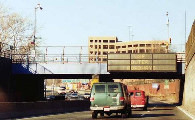 The electronic sign attached to the overpass fascia warns people to use the outer roadways.
What outer roadways?
There's only 3 lanes to choose from. Even if we were to designate each lane as a roadway, there's only one left lane. How many outer roadways could there possibly be?
Or, were they politely suggesting you'd have been better off on a roadway other than that one? In other words, you'd make better time on the narrow, congested, traffic signal and stop sign infested side streets of Brooklyn Heights rather than the one-time state of the art Brooklyn Queens Expressway?
Incidentally, on that fine January 1999 day, traffic was clear on all 3 lanes and I still have no idea what this obviously drunk sign was babbling about.
The building ahead was then a relatively recently built parking garage, serving the downtown civic center traffic. Just past the two green overhead directional signs is Atlantic Avenue, which runs nonstop from here, well into Jamaica, Queens. This section of Atlantic Avenue had many antique shops and Middle Eastern food. The dual carriageway secondary road rests atop a Long Island railroad tunnel that was abandoned for years, until it was "rediscovered" like some archaeological fossil some years back.
The electronic sign attached to the overpass fascia warns people to use the outer roadways.
What outer roadways?
There's only 3 lanes to choose from. Even if we were to designate each lane as a roadway, there's only one left lane. How many outer roadways could there possibly be?
Or, were they politely suggesting you'd have been better off on a roadway other than that one? In other words, you'd make better time on the narrow, congested, traffic signal and stop sign infested side streets of Brooklyn Heights rather than the one-time state of the art Brooklyn Queens Expressway?
Incidentally, on that fine January 1999 day, traffic was clear on all 3 lanes and I still have no idea what this obviously drunk sign was babbling about.
The building ahead was then a relatively recently built parking garage, serving the downtown civic center traffic. Just past the two green overhead directional signs is Atlantic Avenue, which runs nonstop from here, well into Jamaica, Queens. This section of Atlantic Avenue had many antique shops and Middle Eastern food. The dual carriageway secondary road rests atop a Long Island railroad tunnel that was abandoned for years, until it was "rediscovered" like some archaeological fossil some years back.This section of highway pretty much separates the old historic neighborhoods of Red Hook to the left and to the right both Cobble Hill on the north end and Carroll Gardens on the south. The latter two neighborhoods held up much better following the digging of this great divide. Long a traditional and stable Italian dominated neighborhood, Carroll Gardens benefited by also having a couple of subway stops. Even during periods of teetering on the brink of seediness, its core strengths enabled it to weather generational storms. It became a hot spot for hipsters, artsters, yuppies and priced out Manhattan refugees. Cobble Hill meanwhile had the even better advantage of being next door neighbors to ritzy Brooklyn Heights.
Red Hook on the other hand was already a more downtrodden area even before the big dig eviscerated it and left it relatively isolated, with longer walks to the subway and a waterfront that until recently was almost completely given over to workaday wharves and heavy, noisy and smelly truck traffic.
In addition, owing to its huge public housing project, many came to view Red Hook, deservedly or not as a dangerous, crime plagued slum to be avoided.
In latter years it also became increasingly flood prone in major storms and parts of it were doomed to actually end up under water during 2012's Hurricane Sandy. Those disaster prone areas however were the poorest parts of Red Hook, centered around the housing project.
Meanwhile the rest of Red Hook finally experienced a resurgence of late, possibly for the first time in its history, since I'm not sure it was ever NOT a gritty neighborhood. In hindsight, Red Hook's turn at being the place you want to be seems inevitable, given how outlandishly priced its better situated neighbors had gotten. Red Hook's gentrified sections are arguably even more shi-shi than Carroll Gardens at this point. It even has an Ikea.
And all this talk of change leads us to what's changed in our scenery here.
The most obvious change is the thick looking Congress Street overpass holding the spaced out electronic sign directing us to the mythical outer roadway. The bridge bed was reconstructed over the intervening years and Google Earth now shows it faced in cement, so perhaps Congress should be renamed Concrete. The drunk sign was separated from the bridge and is now fastened to a gantry strung between the walls.
The other overpass carrying Kane Street however not only has not been improved over the last two decades, but has clearly visible wood planks shoved into it underbelly to prevent concrete from falling. It's also still wedded to its green Atlantic Avenue exit directional sign.