
Queens Boulevard the Boulevard of Death
 Queens Boulevard is one of several similarly designed, multi-lane, multi-medianed thoroughfares strewn about the 5 boroughs of New York City. It was first widened in the 1920s when it was renamed from Hoffman Road and modeled on the Grand Concourse of the Bronx, which itself was an Americanized attempt to echo the great promenades and boulevards of France. Other cousins of this expansive roadway include Brooklyn's Linden Boulevard, Kings Highway, Eastern and Ocean Parkways, the Richmond Hill section of Woodhaven Boulevard, a short section of Little Neck Parkway, the pre expressway Bruckner Boulevard in the Bronx and pre expressway Horace Harding Boulevard that ran from Queens Boulevard out to the Nassau County line, both of which were later converted to full fledged limited access arterial highways.
 It is probable that the city planned almost from the beginning to transform all of these roads into actual limited access arterial highways and that widening the right of way was just the snide preliminary step to securing the area necessary for an elevated, multi-lane structure. For example, it is known that the Woodhaven Boulevard, Cross Bay Boulevard complex was definitely earmarked to be, more or less over at least part of its long, winding path, the Maspeth Expressway, while Linden Boulevard was the likely intended right of way for the never built Cross-Brooklyn Expressway.
 It's also fair to speculate that the now antiquated Jackie Robinson Parkway, formerly the Interborough, was to continue through East New York on two paths, one westward into Eastern Parkway and another southward through present day Pennsylvania Avenue into the Belt Parkway. Similarly to the west Ocean Parkway was slated to become a full fledged limited access highway extension of the existing Prospect Expressway all the way down to the Belt Parkway, with both abandoned projects tied in to intechanges with not just the unbuilt Cross-Brooklyn, but also the never built Bushwick Expressway that was the intended successor to Atlantic Avenue.
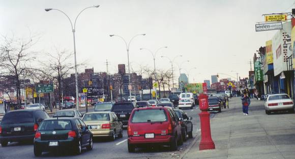
 Growing up in the Queens neighborhood of Rego Park, Queens Boulevard was the center of my childhood universe and probably sparked my initial street lighting interest. It was just so big and my otddler years were spent literally a half a block from it! Now of course, in a less big-friendly age, that is the problem. The Grand are no longer politically correct and anything qualifying as grand must be chopped down to size. By the last decade of the 20th century the inherent dangers to pedestrians along Queens Boulevard became a cause celebre, and with each additional accident and fatality, the cries grew ever louder.
 The death toll suddenly spiked over the winter of 2000-2001 and the local press tagged this great secondary artery as the Boulevard of Death. More forgiving sorts simply referred to it as the Boulevard of Broken Bones. Few challenged the sentiment that a major realignment was needed of the ten drive lanes spread among the three median strips, so that all pedestrians had a safe place to wait out a traffic light before completing their crossings, but some of the reaction to the accidents flew well past the hysterical, given the unfortunate fact that the boulevard was what it was, a vital necessary semi-arterial connector between Jamaica and points east of it to Manhattan.
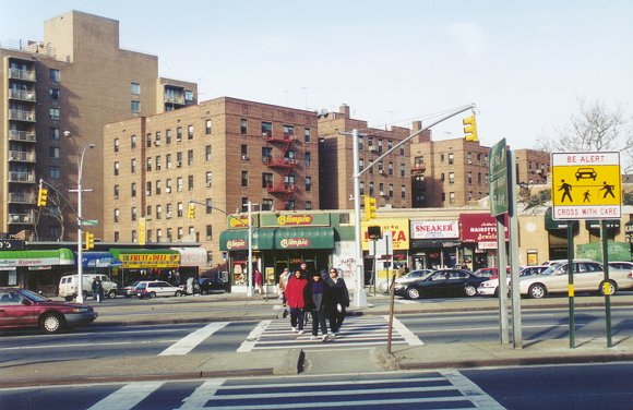 While I was all for reasonable safety measures, I recognized that this was a major sub-arterial, not only leading through the heart of many neighborhoods to and from Manhattan, but itself connecting with a number of other major arteries headed north and south; it wasn't 69th Avenue or Booth Street. Some lunatics demanded speed bumps be installed. As it is, as I update this in 2018, the social engineers in charge of the city already stripped drive lanes and crucial parking spaces in order to widen median strips and add bike lanes. I think that ultimately, cross bridges are needed at various intervals and subway entrance stairwells replaced with ramps, better lighting and full time supervision, including security video surveillance so that they can be safely used where they exist as crossing tunnels, same as so many European cities have at dangerous crossings.
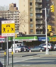 The only other way to get rid of dangerous grade crossings would be to elevate them, creating the very kind of hideous, neighborhood destroying elevated expressway that this road was probably intended to become decades earlier. Not even the dead would vote for that option. The specter of turning Queens Boulevard into Brooklyn's 3rd Avenue is enough to ensure such an option is never chosen. Let's face it Queens; you wouldn't want such an elevated, polluting eyesore in your midst and no such highway is getting built anyway. I think folks need to learn to live with the boulevard pretty much as it is and use common sense rather than stubbornness when crossing.
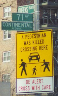
 By Spring 2001, parking meters began going up along the left median curbs of the service roads between Elmhurst and Kew Gardens. The move was intended to slow service road traffic by narrowing the arteries, so to speak. I'm sure the beleaguered DOT's intentions were good, but I saw many flaws in the plan.
1: The median strips were too narrow and offered only one point of egress in many places due to cutouts allowing traffic to pass between the service and center lanes.
2: Many people parking in the middle of long blocks would inevitably jaywalk across the one remaining lane of traffic from their cars to the sidewalk, defeating the whole safety purpose of the plan. In addition, I'm sure this resulted in more jaywalking tickets, with an attendant rise in outrage and backlash that could only have hurt already hard pressed Queens Boulevard businesses and increased the cynical mistrust many New York City residents already felt for the authorities involved.
3: While removing two lanes of traffic that pedestrians needed to cross, it greatly increased congestion, especially since nothing usually stops people from double parking. Parked vehicles also became obstacles to vision, especially when vans and SUVs parked at the corners and cars backing into and out of tight spots were now at greater risk of hitting jaywalking pedestrians, or other drivers trying to reach their own driver side doors.
4: Incidents of road rage and arguments between those stopping to back into a spot and those being held up by them almost certainly burgeoned and likely grew into a non stop nightmare for cops and passersby alike.
By Spring 2001, parking meters began going up along the left median curbs of the service roads between Elmhurst and Kew Gardens. The move was intended to slow service road traffic by narrowing the arteries, so to speak. I'm sure the beleaguered DOT's intentions were good, but I saw many flaws in the plan.
1: The median strips were too narrow and offered only one point of egress in many places due to cutouts allowing traffic to pass between the service and center lanes.
2: Many people parking in the middle of long blocks would inevitably jaywalk across the one remaining lane of traffic from their cars to the sidewalk, defeating the whole safety purpose of the plan. In addition, I'm sure this resulted in more jaywalking tickets, with an attendant rise in outrage and backlash that could only have hurt already hard pressed Queens Boulevard businesses and increased the cynical mistrust many New York City residents already felt for the authorities involved.
3: While removing two lanes of traffic that pedestrians needed to cross, it greatly increased congestion, especially since nothing usually stops people from double parking. Parked vehicles also became obstacles to vision, especially when vans and SUVs parked at the corners and cars backing into and out of tight spots were now at greater risk of hitting jaywalking pedestrians, or other drivers trying to reach their own driver side doors.
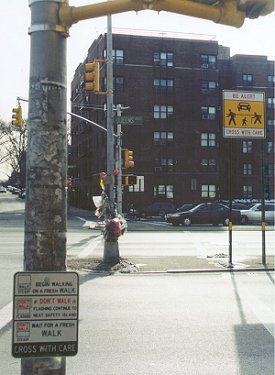
4: Incidents of road rage and arguments between those stopping to back into a spot and those being held up by them almost certainly burgeoned and likely grew into a non stop nightmare for cops and passersby alike.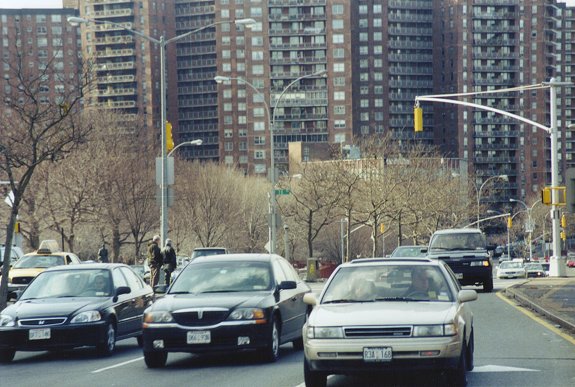 Fast forwarding through the 21st century from 2001 when I had last updated the Queens Boulevard section, the dire death warning signs have disappeared. Google Earth views of some intersections seem to indicate they lasted just over a decade, being removed around 2013. The last views I found with them still standing were from 2012. Myriad fixes appear to have been implemented at some crossings, including wide boxed off pedestrian zones that were extended into what used to be drive or turn lanes, such as is visible at 63rd Drive.
The biggest changes appear to be what in 2018 are the recent installation of bike lanes along the inner curbs of the service lanes, both now reduced to a single drive lane and a single parking lane. A number of local businesses have blamed the subsequent loss of parking on their demise, but life will continue to go on. The smart businesses will adapt to draw as much foot and subway traffic as possible. They have no choice but to do so, simple as that.
An intelligently engineered elevation of the center express lanes would solve many issues here. What I envision working is a double decked highway, 3 eastbound lanes under 3 westbound lanes.
1: If sleekly designed and elevated high enough, no more than four lanes wide at any point, it would let plenty of light underneath.
2: The direct underside could provide additional parking.
3: The service lanes could be widened again to either 2 drive lanes each, or double curbed parking.
4: The center medians would have the space to be substantially widened, not just to give pedestrians more distance from the traffic, but even allow for some greenery, benches, etc.
5: There would be plenty of space for side exit ramps down from both levels and in truth, there really wouldn't be a need for that many exits. I figure from Elmhurst toward Jamaica you'd have exits at 51st Avenue, a combination exit serving the Long Island Expressway and Woodhaven Boulevard, maybe 71st/Continental Avenue or Yellowstone Boulevard, Union Turnpike and ultimately the Van Wyck Expressway, where I envision the arterial highway feeding into and ending.
6: West of 51st Avenue they could probably even bring the six arterial lanes down to a single level at least out to the Brooklyn Queens Expressway interchange, after which they'd probably need to double deck again, or simply dispense with the limited access from there to Manhattan. I would think it would still be better than what they have now.
Try making that happen however. Never in a million years will it come to be.
 One last observation after trolling the historical Google Earth captures of Queens Boulevard through the years. At the 67th Avenue crossing where the young school girl was killed in 2001 the floral tributes were apparently maintained in full through at least 2007. A scraggly remnant is noticeable beneath the doomed Be Alert sign as late as 2012 and even as recently as 2014 the remains of what may have been the final tribute left were visible.
By the summer of 2015, nothing more was left.
One last observation after trolling the historical Google Earth captures of Queens Boulevard through the years. At the 67th Avenue crossing where the young school girl was killed in 2001 the floral tributes were apparently maintained in full through at least 2007. A scraggly remnant is noticeable beneath the doomed Be Alert sign as late as 2012 and even as recently as 2014 the remains of what may have been the final tribute left were visible.
By the summer of 2015, nothing more was left.