
Jackie Robinson Parkway Cypress Hills Avenue East
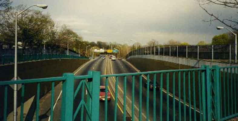 A view of the Jackie Robinson Parkway, looking east from Cypress Hills Avenue, towards the parkway's infamous Cemetery Bend S curves, where traffic must crawl at 25mph.
The Jackie Robinson was known as the Interborough Parkway until May 1997, often spelled Interboro to save space on signs. This parkway, unique among limited access arterial roads within New York City, remained mostly unimproved from it's original 4-lane plan, except for new lighting. Seen here are the "Fatlip" Crouse Hinds OVZ fixtures recently installed, which I've named for the impression their jutting diffusers give me.
As bad as this parkway may be, safety wise, it's far outstripped as an adventurous and torturous drive, by the Westchester section of the ancient Bronx River Parkway. Both parkways give a good idea of what all NYC area parkways used to look like, before widening.
A view of the Jackie Robinson Parkway, looking east from Cypress Hills Avenue, towards the parkway's infamous Cemetery Bend S curves, where traffic must crawl at 25mph.
The Jackie Robinson was known as the Interborough Parkway until May 1997, often spelled Interboro to save space on signs. This parkway, unique among limited access arterial roads within New York City, remained mostly unimproved from it's original 4-lane plan, except for new lighting. Seen here are the "Fatlip" Crouse Hinds OVZ fixtures recently installed, which I've named for the impression their jutting diffusers give me.
As bad as this parkway may be, safety wise, it's far outstripped as an adventurous and torturous drive, by the Westchester section of the ancient Bronx River Parkway. Both parkways give a good idea of what all NYC area parkways used to look like, before widening.The Hutchinson River Parkway, in Westchester County north of The Bronx, is also still 4 lanes wide and retains many original stone bridges.
Two other relatively unimproved parkways north of The Bronx, The SawMill River and Taconic Parkways, are also good examples of primeval parkways, although they barely qualify as arterial roads due to many grade level crossing, and even traffic lights. Whereas the Jackie Robinson can still qualify as a true limited access arterial roadway for its short run, these latter two suburban parkways are sort of hybrids caught in between having limited access arterial status, and secondary road status, as the traffic light strewn Brooklyn's Eastern and Ocean Parkways would be considered.
Several of the Jackie Robinson's overpasses have been altered, or rebuilt, over the years. This one, a plain concrete arched affair, was reconstructed soon after this was shot in 1997.